Oja River Greenway Nature Trail
Route Description
 The union of the Oja River Greenway, which links Ezcaray and Casalarreina along the old railway line, and the Oja-Tirón Green Route, which continues the connection to Haro, in this case via an alternative route to the one followed by the rails of the old narrow-gauge locomotive, results in a route that runs through the Oja Valley, from the mountains and forests of the Sierra de la Demanda to the lands of the Ebro, crossing the Camino de Santiago at Santo Domingo de la Calzada.
Towards the crossing with the Camino de Santiago
The greenway runs for 26.3 km and is paved almost all the way. The route starts next to the old Ezcaray Station (km 0), which now houses a pleasant and charming restaurant with a terrace. However, we recommend that you first stroll around the streets of this mountain town located in an exceptional area, featuring the Demanda, Urbión, Cebollera and Cameros witnesses.
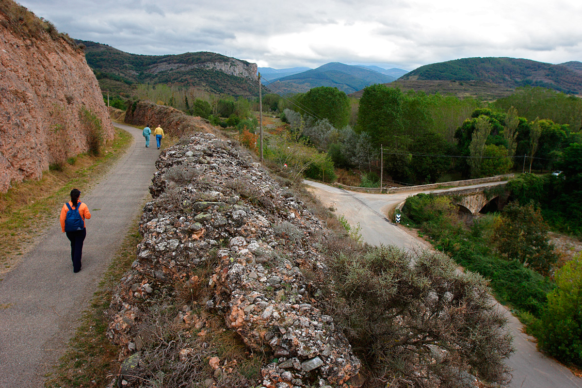
Shortly after starting the route, we can enter a small square that provides access the Chapel of Allende, the town’s patron saint, located on the right of the greenway. The route, which almost sticks to the mountain, borders the limestone cliffs of the San Torcuato crag. We descend to Ojacastro (km 3), passing through Pyrenean oak forests, poplar groves and meadows in what is, without a doubt, one of the route’s most beautiful sections of the route, and a greenway that is highly recommended in the autumn months. As we approach the old station –now used as a spiritual retreat house– we cross a bridge and the greenway overcomes this rugged area thanks to a series of trenches. We continue on our way, leaving behind Ojacastro on the other side of the river, and travel along an elevated route featuring views of meadows with walnut trees and pine and Pyrenean oak forests.
The mountain range gradually merges into the landscape and, after a couple of kilometres, we cross the LR-414 road to Santurde (please be careful!) next to some buildings that have emerged around the old Santurde-Santurdejo Station. From here, the landscape changes significantly and begins to be dominated by large fields of crops next to the flood plain of the Oja River.
We arrive at a footbridge over the Santurdejo Stream, cross the LR-413 road and advance for several kilometres surrounded by cereal fields. In spring and summer, these crops are the breeding habitat of the Montagu's harrier, a bird of prey in that nests on the ground in cereal-growing areas. When we reach the road to Gallinero de Rioja (LR-325), we can stop to rest in an area equipped with benches and fountains. 3 km from Santo Domingo we will see a replica of the original halt of La Carrasquilla. It was once open as a restaurant; hopefully, one day it will be a stopover for travellers again.
Following the unmistakable route we arrive at the pilgrim town of Santo Domingo de la Calzada (km 13), where we will cross another route, the French Way of St. James, which runs through the town. We cannot continue without visiting this beautiful town full of attractions, such as its Plaza Mayor, its main pilgrim route and the cathedral dedicated to “Santo Domingo” (St. Dominic), which houses the saint’s tomb that is located opposite a curious chicken coop (containing a live cockerel and a hen, in reference to the miracle of the Camino de Santiago).
Through poplar groves and farmland
 Back on the greenway, we leave Santo Domingo de la Calzada and cross the ring road through an underpass. We travel 4.5 km before reaching the ruins of the old station of Bañares and a trail that was a Roman road and a Camino de Santiago route until the 12th century. This stretch, which is absolutely straight, we will be able to see isolated specimens of holm oak, whose presence reminds us of the extensive oak groves that occupied these plains before their historical ploughing for agriculture. Shortly thereafter we come across a recreational area and cross a canal. The greenway’s surface disappears for a short time, in a new section that runs parallel to the Castañares de Rioja ring road (km 20) and, after a kilometre, we reach the roundabout that leads to the village. The old station’s buildings are in relatively good condition and are now used for agricultural purposes.
The landscape on both sides is agricultural and on the right there is a row of poplars and alders associated with streams that arise from the Oja aquifer; we then cross an area of poplar trees that will provide us with some of the little shade that this section of the greenway has to offer. To get to Casalarreina (km 26.3), we leave the old railway line and advance along an agricultural road until we come across the path next to the ring road. This takes us to the ring road’s roundabouts; we go through an overpass and take the green route that runs parallel to the LR-111 road.
Green Route to Haro
The green route, which connects with Haro – the starting point of the old Haro-Ezcaray railway– is a pleasant 12-km journey that starts about two kilometres from Casalarreina town centre. Although it does not follow the route of the railway due to difficulties in its restoration, it is an attractive route that runs parallel to the river flowing through the town’s riverside park.
When we reach the Oja footbridge, the route changes riverbank and, after passing under the stone bridge, continues, now along the left bank of the Oja, towards Cihuri. In this section, the riverside grove immerses the trekker in an atmosphere of light and shadow. In this area, and up to the mouth of the Oja aquifer, we will come across beautiful natural alder groves.
The route gradually separates from the river and continues as far as Cihuri through cereal fields, orchards and vineyards. Along the carpeted Molino trail, bordering the poplar groves of another river (the Tirón in this case), the route brings us to one of the most beautiful spots in La Rioja, framed by the magnificent silhouette of the Obarenes hills, Peñas de Gembres and Conchas de Haro. The name Cihuri coms from Zubihuri in the Basque language, which means "town of the bridge," and its most important construction is precisely the Roman bridge of the Priory. The palace-convent itself is also in perfect condition, still featuring its stone coat of arms and graceful bell tower.
"Junta los ríos" viewpoint
Before crossing the bridge to follow the Green Route, we can take a detour of about 400 metres, passing by the winery district, and visit the "Junta los ríos" viewpoint to see where the Oja and Tirón Rivers embrace each other and merge into one.
The next stop is Anguciana. The way to the village passes by a residential area and, after crossing the bridge over the River Tirón, reaches the village centre. The route’s signs guide us through the village to the so-called Camino de la Zarzuela route, where we will meet up with the river and the riverbank again as far as our destination, Haro. Before that, let's learn more about the origin and history of the famous phrase so often repeated by travellers who approached the regional capital’s railway station: "we’re arriving in Haro, you can see the lights." In front of the Arrauri Dam, an information panel describes this town’s energy production and the corporate history of one of its most influential families, the Franceses, who installed electric lighting in one of their factories, which was a first for La Rioja.
After flanking a large vineyard, we go under the motorway and are immediately offered two alternatives to get to Haro. If the case of trekkers, you can choose to follow "El Viano," a beautiful path next to the river. If you are a cyclist, or you want to continue along the Green Route, it is best is to go along the Fuente del Moro trail.
We only have a small ascent left in order to reach Vista Alegre Park, in the urban area of Haro, the wine capital. In the park we can end our route by looking for the bridge that rises over the old railway track. There, we can look out and imagine the silhouette of the "Bobadilla" moving away in a cloud of smoke, as it did for decades on its way to Ezcaray.


