Ojos Negros Greenway (Teruel Section) Nature Trail
Route Description
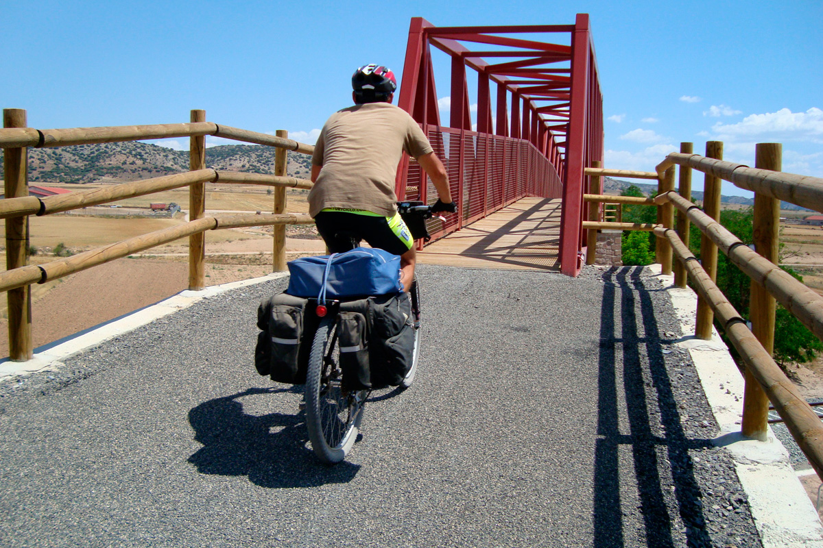
This itinerary between the western part of Teruel and the Valencian coast is – for the moment – the longest Greenway in Spain. Due to its 184-km length, it has been divided into two sections. The province of Teruel is the setting for most of the first stage of the old Sierra Menera mining railway. This journey runs from the Ojos Negros mines (although the 12 km between Peracense and Santa Eulalia have yet to be upgraded), through the Jiloca Valley to the highlands at the foot of the Javalambre and Gúdar mountain ranges, as far as the Palancia Valley in Castellón. It also passes by the impressive Peracense Castle and the vicinity of the city of Teruel. Without a doubt, an itinerary full of nature, culture, diversity and surprises.
The original kilometre posts of the mining road have been respected, with the idea of preserving history and unifying criteria in the two regions. Thus, km 0 is in the Ojos Negros mines (Teruel) and km 204.15 is in Puerto de Sagunto, with signs and kilometre posts being erected along the greenway in accordance with these considerations.
Another peculiarity of this long route is that the track is accompanied almost all along the way by the Valencia-Zaragoza railway line. There are several stops very close to the greenway that provide access to it: Santa Eulalia, Cella, Teruel, Sarrión and Mora de Rubielos. However, it is advisable to check the conditions of access with bicycles on board the trains.
From the Ojos Negros Mines to the Jiloca Valley
Our journey begins! The original route of the railway has its kilometre 0 next to the Ojos Negros Mines, with this 15-km section as far as Peracense being the last one incorporated into the greenway.
However, it should be noted that, if you want, you can start this trip many kilometres earlier since the Ojos Negros Greenway already connects with the Santander-Mediterranean Railway Greenway Nature Trail that comes from as far away as Murero in the province of Zaragoza. That is, about 70 km that run through the regions of Jiloca, Campo de Daroca until it connects with the region of Catalayud –an outstanding project that is being consolidated to turn this route into a long, first-class itinerary!
The mining town of Ojos Negros features an interesting locomotive engine, a vestige of its mining past, which will surely be the first photo of the journey. The route passes by the foot of a magical place: Peracense Castle, which is camouflaged among the reddish rocks dominating the entire plain of Jiloca, a strategic point in medieval times, and dates from the 13th century, being a defensive bastion of the Crown of Aragon. The visit is highly recommended as it was recently fully restored. On to Santa Eulalia, and although the route has not been upgraded, you can continue without much difficulty along agricultural trails and secondary roads.
At km 23, the mining railway separates from the active railway line, leaving the old route to the Ojos Negros Mines free. The actual Ojos Negros Greenway therefore begins at the rest area of Santa Eulalia Station (km 24.2) as mentioned above. It is worth noting that although a "km 23.2" sign appears in Santa Eulalia Station, the correct distance is 24.2. This small one-kilometre difference appears throughout the rest of the route, although this description sticks with the original kilometre signage.
 We will continue our itinerary with a view of enormous cement works beside the road leading to the locality of Santa Eulalia del Campo (about 2 km away). We cross the road carefully and, leaving the factory to our left, we follow the desolate plain of the Jiloca corridor. The landscape features long straight stretches through areas of cereal and watercourses, with only a few trees.
It contrasts with the scenery that we glimpse on the left, in Villarquemado, the neighbouring village: Cañizar Lagoon, one of inland Spain's freshwater wetlands featuring a great variety of fauna and flora. Without any apparent changes in the landscape, we pass by a loading platform (km 33.8) and continue as far as the fertile plain of the Jiloca (km 34). Here, irrigated land and black poplar groves provide both shade and shelter for travellers and a great variety of birds, which liven up our journey after going through such a deserted area.
The greenway then passes under curious "triumphal arches," formed by the remains of flyovers crossing roads and paths, which used to be important features of the railway but are now in disuse. There are also bridges over irrigation channels, e.g. the headwaters of the Jiloca River (km 38.2), with a flow of 3,500 litres per second. Bored in the Middle Ages, it was designed to preserve the Roman channel that, from the surroundings of Albarracín, brought water from the Turia as far as Cella.
We are now close to Cella, an interesting locality due to its brick buildings featuring magnificent eaves and its artesian well, the largest in Europe and the second-largest in the world.
Descent to Alfambra
At km 39,2 there is a level crossing over the busy road from Cella to the dual carriageway junction and to Celadas. Be careful! Be sure to keep your eyes open. On the other side of the asphalt there rises the impressive, futurist Finsa Cella, which has occupied the route and obliges us to go around it along an asphalt road. We re-join the original railway route in the rest area at Cella Station (km 40). Here we change from the Ebro basin to the Turia basin.
At km 45 the old route crosses the CN-234 road by means of an underpass, thereafter rising up above the Adif railway line thanks to an elegant, 30-metre-long metallic footbridge, which replaced the original bridge featuring three metallic arches supported by masonry piles. The route continues through dry farmland. We will soon glimpse the village of Caudé, which the greenway goes around. This detour passes by another rest area, beside the little house where the person in charge of controlling the nearby Caudé reservoir (km 47.5) used to live –this was an important source of water for the steam engines' boilers. Interesting, don't you think?
The greenway continues on surrounded by fields, sharing a section with motor vehicles, mostly agricultural equipment. In this way, we cross a flyover above the "Teruel Norte" turn-off on the Mudéjar dual carriageway and then an underpass (km 50) below the latter, which separates us momentarily from the original route that we re-join about 100 metres further on. At km 51.5, we cross the road from Concud to Celadas by means of a level crossing. Once again, we have to be very careful.
After so many kilometres passing through homogeneous farmland, we glimpse some attractive changes. We can now make out the groves bordering the Alfambra River and enter the first trenches, which mark a change of scenery. Precisely in the trench at km 55.5 we come across a geological curiosity: un unsettling fissure that is caused by a fault. The earth's crust has been sliced like a cake and one of its parts has slid on top of the other, breaking the continuity between one side and the other of the fissure. On one side there are sloping layers (strata) of white stone, and on the other, uniform reddish conglomerate. This important phenomenon is being studied by the University of Zaragoza.
After the bend, the greenway comes to the former Teruel–Los Baños Station. The second part of the compound name refers to a nearby spa. This station used to be an important logistics centre on the railway line, featuring a large engine shed and a small housing estate for railway workers. Here, at the onset of the steep slope up to the Escandón pass, the trains were split into two and reinforced with supplementary engines. In the same place, a level crossing was planned for a railway from Teruel up to Alcañiz that was never built. The ground was only levelled up to 3 km northwards, being followed by a spectacular route full of tunnels, stations and viaducts, hidden away on the banks of the Alfambra –hopefully, one day they will form part of a new greenway connecting us, via Alcañiz, with the present-day Val de Zafán Greenway. (See the North volume of the Greenways Guide).
Going up towards Escandón
 On leaving the former Teruel Santiago, the greenway used to follow a majestic bend, featuring an elegant, curved masonry viaduct over the Alfambra River and the Alcañiz road. However, a few years ago a new slip road for this road to Teruel was built and the junction was made right above the mining railway. Fortunately, the viaduct was not demolished, although its continuation was. Therefore, after passing the viaduct, the greenway leaves the original route. It goes along a trail that passes under the road and then goes back up to the old railway line. After crossing the basin of the Alfambra River, we begin the pronged ascent up to the Escandón pass, along the slopes of the Gorda mountains. At km 58, from the greenway we have wonderful views of the river and Concud plain.
The greenway continues through karst trenches in casts, coming to (at km 59) the Salobral viaduct, popularly known as the "mining bridge," since the gorge that is crosses was the source of crystallised gypsum, whose pieces were so regular that they looked like gems. From here the greenway winds under the dual carriageway's viaducts, crossing it 3 times in less than 2 km.
The first of them (km 59.4) marks the beginning of an agricultural road that goes down to Teruel (about 3 km away), a UNESCO World Heritage City thanks to its magnificent Mudejar art. This detour adds a cultural touch to the route and even enables us to travel back in time –as far back to the Jurassic if we visit the Dinópolis theme park.
Back on the greenway, after going up this road (which is not in a very good condition) out of the city, we experience a change of scenery. The mining railway enters a limestone area of the Seco River's watercourse. At km 61, under the dual carriageway viaduct, on the other side of the watercourse, there is a spring called Peña del Macho and the beginning of a pipeline built in the 16th century to supply the city of Teruel with water.
We continue our ascent up to the Escandón pass and then soon come to an open plain that features peaceful fields, before crossing the dual carriageway again. We therefore have to leave the original railway route to take the flyover on an agricultural road. We re-join the railway route in the surroundings of the road leading to the village of Valdecebro.
We continue upwards as far as the rest area at Valdecebro Station (km 66.05). A little further on, 400 metres way, we cross a rural road that leads directly to the Dinópolis theme park (6 km away) and to the centre of Teruel.
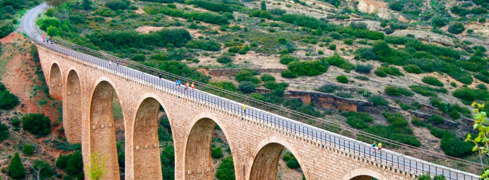
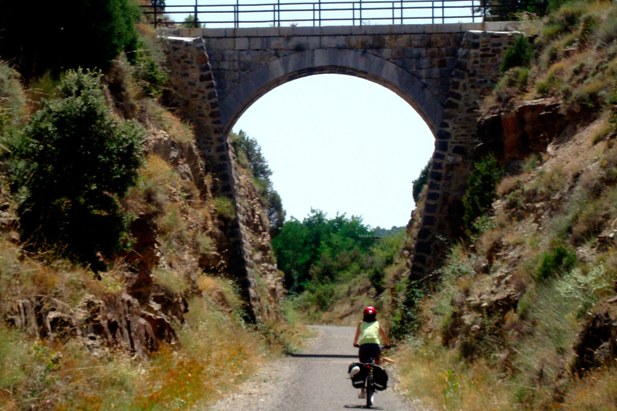
Here we notice another change in the landscape. The relief becomes more rugged, featuring pine forests growing in red soil. We enter our first tunnel and the third on the original railway line. The Valdecebro tunnel (km 69.4) was built for a double-track railway, like the entire section from Teruel–Los Baños Station to the Escandón pass. This was designed (although the double track was not laid in the end)to streamline the traffic and prevent the sector from forming a bottleneck, due to its exceptionally steep slope. The following tunnel at km 73.8 marks the beginning of a section featuring rugged terrain. A little further on, we cross the Especiero viaduct (65 m) and, after one kilometre, the contiguous viaducts of El Francés (77 m) and Los Gatos (104 m) as well as 8 masonry arches and the Mora viaduct (65 m). All of these structures are considerably tall (around 20 m).
The view from the Barranco de los Gatos rest area (km 70.8) enhances our appreciation of these engineering works. As soon as we cross over the last viaduct, we enter the curved, illuminated tunnel of El Puerto or Number 4 (127 m). We continue ascending, but through a less rugged area featuring pines, oaks and junipers. This pleasant itinerary suddenly comes to an end at km 73.8 due to the dual carriageway. The greenway has to take a detour in order to cross it. On the right, there is a turn-off leading to a rural road shared with vehicles and cattle. It goes under the dual carriageway and leads to a service road with shared traffic that, about 700 metres further on, crosses the access to Puerto de Escandón Station, the highest point of the entire route (1,220.5 metres above sea level). In winter, it is freezing cold here.
The descent begins
 The station marks the beginning of an almost continuous descent down to the sea, at Puerto de Sagunto. The first part of this downward trend features a long straight section surrounded by pastureland and shrubland. At km 77.3, we come across the Retamar rest area.
We continue down alongside the active Adif railway life to reach the rest area and the twin stations of La Puebla de Valverde (km 83.10). Here we find the boarding house called La Fonda de la Estación, a beautiful building constructed in the late 19th century to provide lodgings for travellers arriving by train. However, before that, we will have to leave the original route at the entrance of a trench, which was blocked in order to build the road to Camarena. A rural road goes up the level of the road, crosses it and descends again.
A kilometre and a half further on, the dual carriageway affects the mining railway once more. A bend has disappeared, forcing us to leave the original route for about 100 metres along a service road, which takes us across a quarry approach road at a level crossing. Keep your eyes open at this crossroads! We re-join the route opposite the deep Peñaflor Gorge, which is crossed by four parallel bridges, fairly close to each other, which belong to different infrastructures: the Adif railway line, the greenway, the dual carriageway and the CN-234 road.
Each one was built in a different period and reflects a different style... although the one we like best is the bridge featuring elegant, sturdy masonry arches on the old railway line.
Finally, the dual carriageway separates from our route and will no longer bother it until Jérica, in the province of Castellón. Thankful, the greenway now delights us with a wonderful itinerary surrounded by large junipers alternating with holm oaks and acacias. In these groves, it is surprising to come across two stations belonging to the active railway line nearby: La Parra Halt and La Masía del Fraile Station. The latter features the Pozo del Fraile rest area (km 87.8).
We continue descending gently through this bucolic landscape until, at km 91.1, the two railways cross each other for the second time alongside a farmhouse with an enigmatic name: "Tripa Azul" (Blue Belly). Here, the mining railway again passed over its big brother, in this case by means of a metallic structure supported by masonry buttresses. It is surprising that instead of upgrading this bridge by means of a suitable platform, it was decided to take a small detour and make the greenway cross over a masonry bridge on a rural road a few metres away.
Through the hills of Sarrión
Following the slight descent, we enter the area known as La Dehesa, where the rest area of the same name is located (km 93.4). After kilometres travelling through groves featuring wonderful views of the Gúdar mountains, the vegetation becomes scarcer and scarcer, until we come to farmland again. At km 96.9, we reach the rest area at Sarrión Station, which, as is usually the case, is located some distance from the town centre.
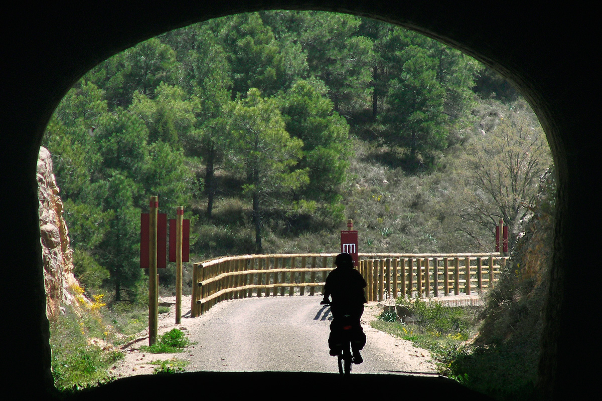
Sarrión, however, is close to the railway line. After passing this locality known for its truffles, there begins another section dotted with gorges and hills that the two railways had to overcome with large engineering works. At km 98.9, a viaduct crosses the watercourse of Los Judíos and then the Sarrión Tunnel (352 m) bores deep into the earth. After coming out of the tunnel, the terrain becomes gentler and, for a few kilometres, it continues without surprises through dry farmland and earth trenches. It is worth stopping at km 101.5 to enjoy looking back at a wonderful view of Sarrión and its church.
A little further on, to the right, a steep road goes down to Mora de Rubielos Station. And after crossing the road to Manzanera, the greenway follows a tight bend leading to Albentosa Tunnel (394 m) or Number 6. The dark, curved gallery has been illuminated. At the other end of the tunnel there is a rest area featuring one of the route's most fascinating views, that of the beautiful masonry viaduct of Albentosa (179 m), which rises up to a height of more than 50 metres above the river on top of 7 arches. In the gorge, the tall black poplars along the banks of the winding Albentosa River look like toy trees. Meanwhile, above our heads, the village of Albentosa is perched on a hilltop, watching over the two viaducts and the river.
However, while it is impressive from above, it is all the more so from below. It is not easy to go down (or come back up); neither is it easy to find and follow the road descending from the village to the river's watercourse. However, once we manage to do so, the impressive view is well worth it, filling our eyes with a view that will make a lasting impression.
The Albentosa marks a turning point and, from here on, the route starts ascending very gently after going down for so many kilometres. Once we pass by the last houses of Albentosa, we go through tunnel Number 7. On leaving the gallery, we travel through a series of groves and trenches on our way to the Las Lomas del Pason rest area (km 107). A little further on, we have another magnificent view of Albentosa, its river and the broad-gauge railway line.
We leave the rugged terrain behind and, after going over a local road by means of a level crossing (be careful!), we come to a rest area and Albentosa Station (km 108.7), which is the last one in the region of Aragon.
Towards the Valencia Region
The greenway continues gently winding through shrubland, scattered juniper trees, farmland and plantations of mycorrhized holm oaks, passing by the Enebrillos rest area (km 110.5). This entire section features wonderful views of the mountains of the Gúdar massif. After passing by the rest area, we cross two viaducts that are both 50 metres long (called El Chopo and La Jaquesa, respectively) and come to the Fuente del Cepo rest area, which is located above a trench.
This rest area marks the end of the Aragonese section of the greenway. However, naturally, we want to continue on and complete this first part of the greenway in Barracas (Castellón), where Renfe trains do not stop but buses do. This nearby town is enthroned as the intermediate point of the Ojos Negros Greenway and as a place to obtain food and accommodation. The old Sierra Menera mining railway continues through the Valencia Region as the Ojos Negros Greenway (Valencia Region section).